")


To fulfill its objective, SixP is based on a consortium with expertise in ecology, metals biogeochemistry, airborne data acquisition, computer visualisation, geostatistics and management of post-mining sites.
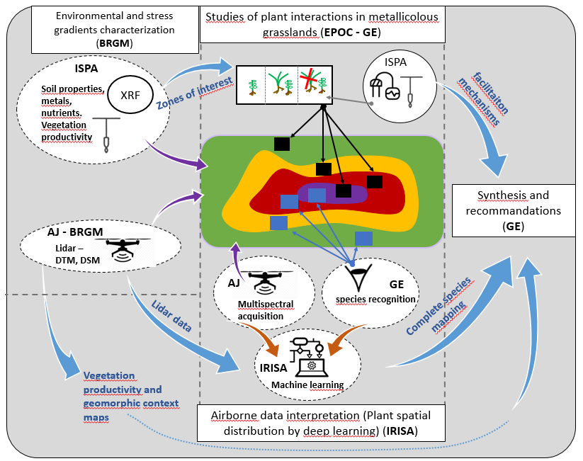
The main role and responsabilities of each partner in the project are presented here. The colored zones represent a site with very high (purple) to low (green) metal concentration in soils.
More specifically:
GE lab : a multidisciplinary lab in environmental science (geology, hydrology, ecology). The projet leader (Florian Delerue) is part of the GE lab. He is an ecologist studying plant community ecology and plant interactions in stressed ecosystems. Other researchers from GE involved are (Olivier Atteia, polluted sites management, geostatistics) and Samia boukir (machine learning)
EPOC ecology lab. The main person involved from EPOC is Richard Michalet who has been studying plant facilitation for two decades in many systems, including mountain areas.
ISPA biogeochemistry lab, the main participants are Valérie Sappin-Didier and Christophe Nguyen. They study the transfer of metal contaminants from soil to plants.
The BRGM is the national geological survey of France. The main participants are Gaël Bellenfant and Thomas Dewez whose respective expertise are in post-mine sites management, and interpretation of geomorphological data from LIDAR and photogrammetry.
At IRISA computer science lab, and more precisely within the OBELIX group focusing on Artificial Intelligence for Earth and Environment Observation, two researchers are involved: Sébastien Lefèvre, leading the OBELIX group, with expertise in deep learning applied to remote sensing; and Thomas Corpetti, with complementary expertise in estimation of biophysical variables from remote sensing data.
L’Avion Jaune (AJ) is a remote sensing company with experience in research projects for environment and geomorphology. Michel Assenbaum, one of the co-founders of the company, coordinates a team of remote sensing specialists and pilots who perform the on-site LIDAR and multispectral data acquisition from the air.
Several PhD students and post-doctoral fellows strengthen the project team working in the different disciplines covered by the project. Several technicians from the different partners also help with the different tasks.
Note that the project implementation is eased thanks to the local french national forestry office (ONF, studied sites are within areas managed by the ONF), local institutions (Sentein council) providing material support) and different stakeholders (the Relais montagnard Gîte, sheep herders).